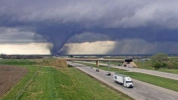
Tornado Sighting: Nebraska DOT Camera Witnesses Storm’s Approach near I-80 , Iowa on Alert

Date:

Share post:

Waverly, NE – A Nebraska Department of Transportation camera stationed along I-80 captured a startling image of a tornado near Waverly as part of a significant storm system moving through the area. 

The image, timestamped just before 3 PM, showcases the severity of the storms now heading toward Iowa and Illinois. The current trajectory of these systems indicates that they could impact regions later today, with the potential for severe thunderstorms to develop. 

Authorities urge residents to stay updated on the latest weather reports and to be prepared to seek shelter if severe weather warnings are issued.

LEAVE A REPLY

Please enter your comment!
Please enter your name here

This site uses Akismet to reduce spam. Learn how your comment data is processed.

Related articles

NWS: New York Tornado: EF-1 Touched Down in Chenango County July 15th

Chenango County, NY - An EF-1 tornado was confirmed by National Weather Service (NWS) meteorologists in Lincklaen and...

Severe Storm Warning Issued for Northwest Minnesota: Prepare for Large Hail and Tornadoes

Thief River Falls, MN – Thunderstorms are developing in northwest Minnesota, with the potential for severe weather this...

Major Accident in Addison: Dump Truck Rollover Leads to Road Closure

Addison, IL - A major accident involving a dump truck and another vehicle occurred at the intersection of...

Wyoming Flash Flood Warning Issued for Torrington Area Until 7:30 PM MDT

Cheyenne, WY - The US National Weather Service in Cheyenne has issued a flash flood warning for Torrington...